

10 Beautiful Easy Trails in Boulder
Ten easy Boulder hikes with big views, picked by a mountain guide and his wife

Here are the 10 we keep going back to. Under each map photo there's a link to the route, and one heads up: Boulder sits at about 5,300 feet, so even easy trails can leave you winded the first few days.
1. Chautauqua Trail

Link on map: Chautauqua Trail route on TrailyMap

Distance: about 1.5 miles (up the Chautauqua Trail, back down Bluebell Road)
Elevation gain: around 450 ft
Difficulty: easy, with one steady climb
Trailhead: Chautauqua Park, off Baseline Road
This is the postcard trail. You walk out of Chautauqua Park across a big open meadow, and the Flatirons sit right in front of you the whole way, getting bigger with every step. If you only have one hour in Boulder, this is the one.
It's short, but it does climb, so we took it slow and stopped a lot for photos. We came back down on Bluebell Road, a wide gravel road that's much kinder to tired legs. My wife still managed to trip on the one rock in the middle of the meadow path, which honestly felt like a tradition at that point. The historic Chautauqua Dining Hall is right by the trailhead if you want breakfast after.
2. Flatirons Vista Loop

Link on map: Flatirons Vista Loop route on TrailyMap

Distance: about 3.5 miles (loop)
Elevation gain: around 270 ft
Difficulty: easy
Trailhead: Flatirons Vista Trailhead on Highway 93, just south of town
If Chautauqua is the Flatirons up close, this one is the Flatirons as a full panorama. The loop runs through open grassland south of town, and the whole time the rocks are lined up on the horizon like someone arranged them for a photo. It's the trail I'd pick for a first easy hike in Boulder if you want views without any real climbing.
The path is wide gravel for the most part, with a short rocky stretch through ponderosa pines on the south side. Watch for prairie dogs popping up in the fields, they're everywhere. There's a small parking fee if your car isn't registered in Boulder County, and the trail closes when it's too muddy, so check the city's trail page after rain or snow.
3. Wonderland Lake Trail

Link on map: Wonderland Lake Trail route on TrailyMap

Distance: about 1.8 miles around the lake (or 2.5 miles with Wonderland Hill)
Elevation gain: around 100 ft for the lake loop
Difficulty: very easy
Trailhead: Foothills Nature Center lot, 4201 North Broadway
This was my wife's first hike after the baby, and I picked it on purpose. It's a mostly flat loop around a lake in north Boulder, on smooth crushed gravel, with the foothills right behind the water. Ducks, herons, people fishing, the whole peaceful neighborhood vibe.
If you feel good, add the short climb up Wonderland Hill. On a nice day you'll see paragliders launching from the hilltops and floating down toward the lake, which is way more entertaining than it sounds. Parking is free in the lot at 4201 North Broadway, next to the Foothills Nature Center. Zero falls on this one, by the way. A personal record for my wife.
4. Sanitas Valley Trail

Link on map: Sanitas Valley Trail route on TrailyMap

Distance: about 2.6 miles round trip
Elevation gain: around 600 ft
Difficulty: easy to moderate
Trailhead: Centennial Trailhead on Sunshine Canyon Drive
Mount Sanitas is one of Boulder's favorite workouts, and the ridge route to the summit is steep and rocky. That's a no for us right now. The good news is the Sanitas Valley Trail, which runs up the wide, grassy valley right next to it on smooth gravel. Same scenery, a fraction of the suffering.
It climbs gently the whole way, so it's a nice step up once the totally flat trails start feeling easy. In summer the valley is full of wildflowers, and looking back down you get Boulder and the Flatirons behind you. There's basically no shade, so go early. And yes, as a climber I did stare at the rocks on the ridge the entire time. My wife caught me every single time.
5. Fowler Trail (Eldorado Canyon)

Link on map: Fowler Trail (Eldorado Canyon) route on TrailyMap

Distance: about 1.8 miles round trip
Elevation gain: around 150 ft
Difficulty: very easy
Trailhead: inside Eldorado Canyon State Park, off Eldorado Springs Drive
Eldorado Canyon is one of the most famous climbing spots in the country, and normally I'd be on those walls with a rope. This time I was down on the Fowler Trail holding my wife's water bottle, and I have zero regrets. The canyon is so beautiful that you don't need to climb anything to feel it.
The trail follows an old railroad grade that was graded back in the 1800s but never got its tracks, so it's wide and almost flat, and part of it is even wheelchair friendly. Golden red cliffs rise on both sides, and there are viewing scopes along the way to watch climbers on the walls. I may have spent a little too long at those scopes explaining routes to my wife. Eldorado is a state park, so there's a daily vehicle fee, and on busy summer weekends it's smart to check the park's website for entry reservations before you drive out.
6. Red Rocks Trail (Settlers Park)

Link on map: Red Rocks Trail (Settlers Park) route on TrailyMap

Distance: about 1.2 miles (loop)
Elevation gain: around 230 ft
Difficulty: easy, with a couple of short steep bits
Trailhead: Settlers Park, at the west end of Pearl Street
This is the easiest "real hike" you can do in Boulder without a car. Settlers Park sits at the west end of Pearl Street, so you can stroll past the shops downtown and five minutes later you're climbing between big fins of red sandstone. It feels kind of unreal how close it is.
The loop is short, but it has a couple of steep, eroded spots where the gravel likes to roll under your feet. You can guess who found that out first. Take it slow there and you'll be fine. From the top you get the city, Mount Sanitas and the Flatirons all in one view, and you'll often see people bouldering on the rocks. It's a great spot for golden hour photos too.
7. Anne U. White Trail

Link on map: Anne U. White Trail route on TrailyMap

Distance: about 3.2 miles round trip
Elevation gain: around 450 ft
Difficulty: easy
Trailhead: end of Pinto Drive, northwest of town
This one feels like a secret, even though it really isn't. The trail follows Fourmile Canyon Creek up a narrow, shady canyon just northwest of town, with the water next to you pretty much the entire time. On a hot afternoon it's easily 10 degrees cooler in there than in the city.
The climb is so gradual you barely notice it, which my wife appreciated. What she did notice were the creek crossings. There are about 25 of them, mostly on stepping stones, and I'll just say one of them ended with a wet shoe and a lot of laughing. If you're as graceful as she is, bring a spare pair of socks. At the end there's a small waterfall that's perfect for a snack break. The lot only fits about 28 cars, so try to come early or on a weekday.
8. NCAR Trail

Link on map: NCAR Trail route on TrailyMap

Distance: about 1.5 miles round trip
Elevation gain: around 250 ft
Difficulty: easy
Trailhead: NCAR Mesa Lab, at the top of Table Mesa Drive
The drive up is half the fun here. Table Mesa Drive dead-ends at the National Center for Atmospheric Research, a pink concrete building designed by I. M. Pei that looks like it grew straight out of the mesa. The trail starts right behind it, and the first stretch has little signs explaining how weather works, which my wife read out loud like a tour guide. I'm the guide for a living, so I let her have this one.
From there it's a gentle rolling walk along the mesa with the Flatirons straight ahead and Bear Peak towering over everything. We saw a small herd of mule deer grazing just off the trail, completely unbothered by us. If you're feeling good, the trail keeps going down to the Mesa Trail, but honestly the views from the top section are the best part, and that's where we turned around.
9. Long Lake Loop (Brainard Lake)
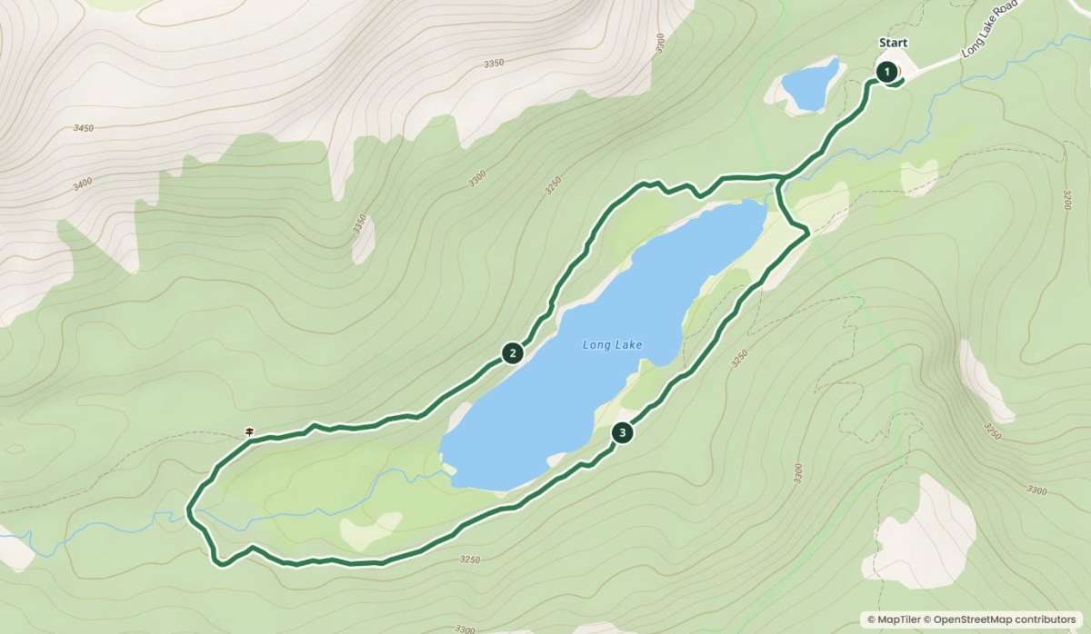
Link on map: Long Lake Loop (Brainard Lake) route on TrailyMap

Distance: about 2.5 miles (loop)
Elevation gain: around 250 ft
Difficulty: easy, but at high altitude
Trailhead: Long Lake Trailhead, Brainard Lake Recreation Area
If you want one trip that feels like a postcard of the Colorado Rockies, this is it. Long Lake sits at over 10,000 feet in the Indian Peaks Wilderness, about an hour's drive from Boulder, with jagged peaks rising right behind the water. The loop around it is mostly flat and wide, with little wooden bridges over the creek.
The trail is easy, the air is not. At that elevation even a gentle walk gets your heart going, so we took it really slow and stopped every time my wife wanted to, which was often and completely fair. The marshy shore is prime moose territory, so keep your eyes open and give them a lot of space if you see one. Brainard Lake Road is usually only open from about mid-June to mid-October, and in summer you need a timed entry reservation on recreation.gov, so book ahead.
10. Boulder Creek Path into Boulder Canyon

Link on map: Boulder Creek Path into Boulder Canyon route on TrailyMap

Distance: about 3 miles round trip from Eben G. Fine Park (or as far as you like)
Elevation gain: around 150 ft
Difficulty: very easy
Trailhead: Eben G. Fine Park, at the west end of Arapahoe Avenue
This is our recovery day walk, the one we do when legs are tired but we still want to be outside. The Boulder Creek Path runs right through town, and if you start at Eben G. Fine Park and head west, the pavement soon turns into packed gravel and follows the creek up into Boulder Canyon. Within ten minutes the city disappears and it's just rock walls, pine trees and the sound of water.
It's shared with bikers and runners, so stay to the right. On warm summer days you'll see people tubing down the creek and families wading in by the park, which is half the entertainment. The grade is so gentle that you can turn around whenever you want. My wife insists she has never fallen on this path. I have video of two very close calls. We agreed to disagree.
That's our list. None of these will impress the summit crowd, and that's exactly the point. Boulder is one of those rare places where the easy trails are just as beautiful as the hard ones, and you don't have to earn the view with a sufferfest. If you're coming back from a baby, an injury or just a long winter on the couch, start with Wonderland Lake and work your way up to Long Lake.
If you made me pick one, it's the Fowler Trail, mostly because I got to watch climbers all afternoon. My wife would pick Chautauqua, because of the breakfast after. Trail conditions and parking rules change, so check the city's Open Space and Mountain Parks site before you head out. And if you know an easy, beautiful trail around Boulder that I missed, tell me. We're only here for a while, and we want to see as much as we can