

10 Best Dark Sky Parks for a Night Hike in the U.S.
Ten certified dark sky parks with a short trail for sunset or after dark, and when to go for the best stars.

These Dark Sky Parks are certified by DarkSky International, and each has a short trail for a sunset or after-dark walk. Where a park does not encourage night hiking, I point you to a spot to watch the sky from instead.
Plan around the moon: a new moon gives the most stars, a full moon lights sand well enough to walk without a lamp. Scout the trail in daylight, carry a headlamp with a red mode, and pack a warm layer.
 Numbers on the map match the list below.
At a glance
Owachomo Bridge, UT · 0.6 mi · hard · a night walk the NPS invites, in the first International Dark Sky Park · Link to route map
Mesquite Flat Sand Dunes, CA · 2.3 mi · hard · a ranger-recommended night stroll in Death Valley · Link to route map
High Dune, CO · 4.1 mi · moderate · a full-moon climb up a 690-foot dune · Link to route map
Window View Trail, TX · 0.3 mi · easy · a paved sunset loop under Big Bend’s dark sky · Link to route map
Bristlecone Trail, NV · 4.0 mi · moderate · ancient pines near 10,000 feet, then stars at Mather Overlook · Link to route map
Grand View Point, UT · 1.5 mi · easy · the start point for Island in the Sky ranger star programs · Link to route map
Warner Point, CO · 1.6 mi · easy · a sunset rim walk in a park that never closes · Link to route map
Cap Rock, CA · 0.8 mi · easy · a short loop next to an official stargazing lot · Link to route map
Grand Canyon Rim Trail, AZ · 1.9 mi · easy · a paved rim walk toward Mather Point · Link to route map
Headlands, MI · 3.2 mi · easy · a Great Lakes shore open to stargazers all night · Link to route map
Quick picks
Best real night hike: Owachomo Bridge (#1) and Mesquite Flat Sand Dunes (#2)
Best for beginners and families: Window View Trail (#4) and Headlands (#10)
Best full-moon walk: High Dune (#3)
Most unusual company: the bristlecone pines on the Bristlecone Trail (#5)
1. Owachomo Bridge, Natural Bridges National Monument, Utah

 Route map
Distance 0.6 mi · Elevation gain 135 ft · Hard · About 30 min · Best time: new moon, spring and summer
Why it made the list: Natural Bridges became the first International Dark Sky Park on March 6, 2007, and the NPS says adventurous visitors can hike to Owachomo Bridge after dark.
Owachomo is the smallest of the monument’s three natural bridges and may be the oldest: 106 feet high, with a 180-foot span that has thinned to just 9 feet thick. The trail drops 188 feet on wooden and rock stairs to the base, where the sandstone frames a slice of sky.
Guide’s tip: walk down once before sunset so you know where the stairs turn, and stay clear of the steep canyon sides.
Good to know: Natural Bridges trails are open day and night. The NPS suggests warm layers and a flashlight for this walk.
Link to map, GPX and directions
2. Mesquite Flat Sand Dunes, Death Valley, California

 Route map
Distance 2.3 mi · Elevation gain 85 ft · Hard · About 1.5 h · Best time: October to April, full moon for walking or new moon for stars
Why it made the list: Death Valley earned Gold Tier International Dark Sky Park status in February 2013, and rangers list Mesquite Flat Sand Dunes among their top stargazing spots.
The dunes sit just east of Stovepipe Wells Village off CA-190, and the highest rises only about 100 feet. There are no official trails. The NPS suggests a casual night stroll here rather than a hike over rocky ground.
Guide’s tip: come at sunset for the long shadows, then stay. Pick a full moon to walk by natural light, a new moon for stars.
Good to know: Summer nights here can stay above 100°F, and the NPS advises against hiking after 10 a.m. in summer. Carry water and a red-filtered flashlight.
Link to map, GPX and directions
3. High Dune, Great Sand Dunes, Colorado

 Route map
Distance 4.1 mi · Elevation gain 600 ft · Moderate · About 2.5 h · Best time: late summer and early fall, full moon or moonless
Why it made the list: Great Sand Dunes became an International Dark Sky Park in 2019, and its superintendent said it has some of the darkest skies measured in the West.
From Dunes Parking you cross about half a mile of Medano Creek bed, then zigzag up the ridgelines to High Dune, about 690 feet from base to top. Rangers suggest a full moon to walk without a lamp, or a moonless night for the most stars.
Guide’s tip: before you start, note where Dunes Parking sits in relation to the line of cottonwood trees, as the NPS advises, so you can find your car in the dark.
Good to know: Summer afternoon sand can reach 150°F, so climb in the evening, and avoid the dunes in lightning.
Link to map, GPX and directions
4. Window View Trail, Big Bend, Texas

 Route map
Distance 0.3 mi · Elevation gain 62 ft · Easy · About 15 min · Best time: new moon, fall to spring
Why it made the list: Big Bend became a Gold Tier International Dark Sky Park in 2012, after NPS measurements found the darkest measured skies in the lower 48 states.
This paved, wheelchair-accessible loop circles a low hill near the Chisos Basin parking lot, with views of the peaks around the basin and through the Window, a notch in the mountains. Benches along the way face what the NPS calls a classic Big Bend sunset.
Guide’s tip: check the ranger schedule for star parties and moonlight walks, a safer way to see the Chisos after dark than a long trail.
Good to know: Mountain lions live in the park, and the NPS asks hikers to keep children close. The NPS cancelled the planned 2026 Chisos Basin closure. Entry is $30 per vehicle for 7 days.
Link to map, GPX and directions
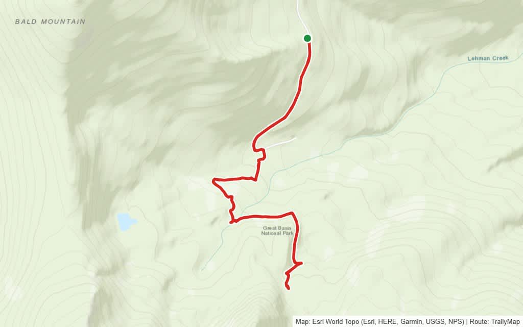
5. Bristlecone Trail, Great Basin, Nevada

 Route map
Distance 4.0 mi · Elevation gain 656 ft · Moderate · About 2.5 h · Best time: summer, on a moonless night
Why it made the list: Great Basin has been a Gold Tier International Dark Sky Park since 2016, and the NPS says one of its bristlecone pines, Prometheus, reached about 5,200 years.
The Bristlecone Trail starts near 9,890 feet at the end of the Wheeler Peak Scenic Drive and climbs to a grove of twisted pines below Wheeler Peak. This route begins at the Summit Trailhead, adding a little distance. It is high, rocky ground, so plan to be back at the car by dusk.
Guide’s tip: on the drive down, stop at Mather Overlook, one of the park’s recommended stargazing spots, and wait for the Milky Way.
Good to know: The scenic drive closes each fall for ice and snow and reopens in spring or early summer. Ranger astronomy programs run Thursday to Sunday in summer.
Link to map, GPX and directions
6. Grand View Point, Canyonlands, Utah

 Route map
Distance 1.5 mi · Elevation gain 322 ft · Easy · About 1 h · Best time: spring and fall, new moon
Why it made the list: Canyonlands was named a Gold Tier International Dark Sky Park in 2015, and Island in the Sky ranger night sky programs begin at Grand View Point.
A paved sidewalk leads to the first viewpoint, and the trail continues about a mile along the canyon edge to a second one. From there you look over the White Rim Road, The Maze and The Needles. Walk out for sunset, then watch the stars from the paved overlook.
Guide’s tip: the trail is rough, with stone steps, and follows the rim. Walk back in twilight with a headlamp on red rather than in full dark.
Good to know: Ranger night programs run here occasionally in spring and fall. Dogs are not allowed on the trail.
Link to map, GPX and directions
7. Warner Point, Black Canyon of the Gunnison, Colorado

 Route map
Distance 1.6 mi · Elevation gain 295 ft · Easy · About 1 h · Best time: summer, near the new moon
Why it made the list: Black Canyon of the Gunnison became an International Dark Sky Park in 2015, and the park never closes, so night sky viewing is allowed at all hours.
Warner Point starts at High Point, the end of the South Rim Road. The trail runs along a ridge with the San Juan Mountains and Uncompahgre Valley to the south and the West Elk Mountains to the north, and ends above the Gunnison River. It is steep in places, so treat it as a sunset walk.
Guide’s tip: after sunset, drive to Sunset View or Dragon Point Overlook, both on the park’s list of South Rim stargazing spots.
Good to know: The road past the visitor center is usually open to cars from late April to mid-November. Pets are not allowed.
Link to map, GPX and directions
8. Cap Rock, Joshua Tree, California

 Route map
Distance 0.8 mi · Elevation gain 16 ft · Easy · About 30 min · Best time: moonless summer nights for the Milky Way
Why it made the list: Joshua Tree was certified as an International Dark Sky Park in 2017, and the Cap Rock parking lot is one of its four designated stargazing areas.
This mostly flat dirt loop winds between Joshua trees, Mojave yuccas and granite formations, including the boulder perched on top of a rock that gave Cap Rock its name. Walk it at dusk, then stargaze from the lot.
Guide’s tip: bring a folding chair. At the designated stargazing lots the park asks you to stay within 20 feet of your vehicle, so the best seat is next to your car.
Good to know: Use red light only: your eyes need 20 to 30 minutes to adjust to the dark, and bright light sets that back. Pets are not allowed on the trail.
Link to map, GPX and directions
9. Grand Canyon Rim Trail, Arizona

 Route map
Distance 1.9 mi · Elevation gain 131 ft · Easy · About 1 h · Best time: June to October, near the new moon
Why it made the list: Grand Canyon earned full International Dark Sky Park status in June 2019 after retrofits brought 69% of its more than 5,000 outdoor lights up to dark-sky standards.
The Rim Trail runs about 13 miles along the South Rim, most of it paved. From Grand Canyon Village it heads east toward Yavapai Point and Mather Point, which is often recommended for stargazing in the village.
Guide’s tip: for real darkness, wait at least 1.5 hours after sunset and pick a night near the new moon.
Good to know: Water is available in the village, at the Yavapai Geology Museum and at the visitor center, and lightning often strikes the rim in summer storms. After dark, keep your light on red.
Link to map, GPX and directions
10. Headlands International Dark Sky Park, Michigan
 Route map
Distance 3.2 mi · Elevation gain 115 ft · Easy · About 1.5 h · Best time: new moon, after astronomical twilight, summer to fall
Why it made the list: The Headlands became the sixth International Dark Sky Park in the U.S. in May 2011, and DarkSky named it the 2017 International Dark Sky Place of the Year.
The Headlands is about 600 acres of woods with more than two miles of undeveloped Lake Michigan shoreline, just west of Mackinaw City on the Straits of Mackinac. This loop starts at nearby McGulpin Point Lighthouse and reaches the Dark Sky Viewing Area on the shore. From the park entrance, the paved, one-mile Dark Sky Discovery Trail leads to the same viewing area.
Guide’s tip: the main Headlands lot is small and the line to get in can be long, which is one reason to start from McGulpin Point. Arrive before sunset either way.
Good to know: The grounds, trails and viewing areas are open 24 hours a day, every day, and there is no entrance fee. Camping is not allowed. Bring a red-filtered flashlight, and park with your headlights aimed away from the shore and viewing areas.