

10 Best Swimming Holes in the U.S. Worth the Hike
Ten hikes to natural swimming holes, from Havasu Falls to a Maine gorge, with permits and safety notes.

These are 10 hikes to the best swimming holes in the U.S., from a 70°F creek in a side canyon of the Grand Canyon to a 3-mile gorge in the Maine woods. Swimming is allowed at all of them in 2026, though some close the water after rain, and six of the 10 routes are rated easy.
None of these spots has a lifeguard. Rain upstream can raise a creek in minutes, and the National Weather Service warns that six inches of fast water can knock you off your feet. Mountain water stays cold even in August, so ease in, check the depth first, and never jump or dive where it is banned.
 Numbers on the map match the list below.
At a glance
Havasu Falls, AZ · 10.5 mi · hard · 70°F water all year, 10 miles down a canyon · Link to route map
Lower Calf Creek Falls, UT · 2.9 mi · easy · a 126-foot fall into a pool in the desert · Link to route map
Punch Bowl Falls, OR · 7.7 mi · moderate · a deep, bowl-shaped pool below the falls · Link to route map
Hamilton Pool, TX · 1.6 mi · easy · a 50-foot fall into a collapsed grotto · Link to route map
Cummins Falls, TN · 2.3 mi · easy · wade up a gorge to a 75-foot waterfall · Link to route map
Midnight Hole, NC · 4.6 mi · moderate · a swimming hole below a 6-foot drop in the Smokies · Link to route map
Devil’s Bathtub, VA · 2.0 mi · easy · a rock basin 10 to 12 feet deep · Link to route map
Glade Creek, WV · 2.8 mi · easy · cascades and pools on an old railroad grade · Link to route map
Diana’s Baths, NH · 1.1 mi · easy · shallow pools on an accessible path · Link to route map
Gulf Hagas, ME · 7.9 mi · moderate · pools below falls in a 3-mile gorge · Link to route map
Quick picks
Best for families: Diana’s Baths (#9) and Glade Creek (#8)
Warmest water: Havasu Falls (#1)
Best deep pool: Devil’s Bathtub (#7) and Punch Bowl Falls (#3)
Most unusual: Hamilton Pool (#4)
Best full-day adventure: Gulf Hagas (#10)
1. Havasu Falls, Arizona

 Route map
Distance 10.5 mi one way · Elevation gain 2,621 ft · Hard · About 6 h · Best season: spring and fall
Why it made the list: The creek below Havasu Falls stays about 70°F all year, and the falls sit 10 miles down a side canyon of the Grand Canyon on the Havasupai Reservation.
The Havasupai Trail drops from Hualapai Hilltop through a dry red canyon to the village of Supai, 8 miles in, then 2 more miles to Havasu Falls and the campground. Mooney Falls is half a mile farther.
Guide’s tip: start before dawn. Summer highs can reach 115°F, and the trail closes when it gets hotter than that.
Good to know: No day hikes. Every visitor needs a 3-night reservation from the Havasupai Tribe; a 2026 campground permit costs $455 per person. The campground is open Feb. 1 to Nov. 30. Pets are not allowed.
Flash floods are most likely from July to September. If it storms, get to high ground.
Link to map, GPX and directions
2. Lower Calf Creek Falls, Utah

 Route map
Distance 2.9 mi one way · Elevation gain 112 ft · Easy · About 3 h · Best season: March to June, September and October
Why it made the list: Calf Creek drops 126 feet into a swimming pool at the end of a sandy canyon walk past Fremont granaries built more than 800 years ago.
This trail in Grand Staircase-Escalante follows Calf Creek up a sandstone canyon, about 3 miles each way (6 miles round trip). Watch the cliffs for granaries and three large figures painted in red. At the end, the falls pour into a cold, shaded pool.
Guide’s tip: arrive early on summer weekends, when the pool gets crowded, and use waterproof sunscreen so you do not pollute the creek.
Good to know: Hikers pay a $5 day-use fee per vehicle. Dogs must be on a leash.
Summer thunderstorms cause flash floods in this canyon, and in 2025 the BLM warned swimmers about rocks falling from the cliff beside the falls.
Link to map, GPX and directions
3. Punch Bowl Falls, Oregon

 Route map
Distance 7.7 mi · Elevation gain 873 ft · Moderate · About 4 h · Best season: July to September
Why it made the list: About 2 miles up the Eagle Creek Trail in the Columbia River Gorge, the creek pours through a narrow channel into the deep, bowl-shaped pool that gave the falls its name.
The Eagle Creek Trail runs along steep cliffs above the creek to Punch Bowl Falls, where the water shoots out of a narrow channel into a round, deep pool. This route keeps going upstream to Loowit Falls before you turn around.
Guide’s tip: even in August this creek is cold. Keep swims short, and keep kids close on the cliff sections of the trail.
Good to know: Swimmers use the pool, but jumping or diving off Punch Bowl Falls is prohibited.
Parking costs $5 per vehicle per day, or use a recreation pass. Dogs must be leashed.
Link to map, GPX and directions
4. Hamilton Pool, Texas

 Route map
Distance 1.6 mi · Elevation gain 56 ft · Easy · About 1 h · Best season: May to September
Why it made the list: Hamilton Creek pours over limestone in a 50-foot waterfall into a pool inside a collapsed grotto, formed by thousands of years of erosion.
West of Austin, a steep, uneven quarter-mile path drops from the parking lot to a round pool under a huge limestone overhang, with a waterfall dropping from the lip of the old cave roof.
Guide’s tip: book the morning slot, when it is cooler, and call the info line before you drive out to check if swimming is open.
Good to know: Reservations are required every day: $12 per vehicle, plus $8 per adult in cash. No pets.
Swimming is allowed only from the beach and depends on bacteria levels and rain. The water can drop below 50°F in winter and spring.
Link to map, GPX and directions
5. Cummins Falls, Tennessee

 Route map
Distance 2.3 mi · Elevation gain 210 ft · Easy · About 2 h · Best season: June to September
Why it made the list: Cummins Falls is 75 feet high and Tennessee’s eighth-largest waterfall by volume, and Travel Leisure put it on its list of America’s best swimming holes.
A steep path drops into the gorge of the Blackburn Fork River, and you wade upstream to the base of the falls, which drop 75 feet in two steps into a swimming hole.
Guide’s tip: wear water shoes with good grip and pack light, because you will be wading.
Good to know: You need a Gorge Access Permit, sold online, to enter the gorge or reach the base of the falls. The gorge closes at 5 p.m.
The gorge is prone to flash floods, and swimming closes when water is high. Kids 12 and under must wear a life jacket.
Link to map, GPX and directions
6. Midnight Hole, North Carolina

 Route map
Distance 4.6 mi · Elevation gain 666 ft · Moderate · About 2.5 h · Best season: June to September
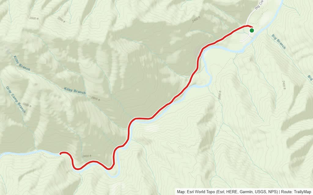
Why it made the list: In Great Smoky Mountains National Park, Big Creek pours over a 6-foot drop into a deep pool 1.4 miles in, and 41-foot Mouse Creek Falls is half a mile farther.
The Big Creek Trail follows an old logging railroad grade, climbing gently beside the creek to Midnight Hole, a deep, emerald pool. Keep going to Mouse Creek Falls, which cascades into Big Creek.
Guide’s tip: Hurricane Helene changed this spot. The beach is smaller and a fallen tree lies across the old jumping rock, so check the pool first.
Good to know: Cars parked over 15 minutes need a park parking tag: $5 a day.
The trail is closed beyond Mouse Creek Falls because of storm damage.
Link to map, GPX and directions
7. Devil’s Bathtub, Virginia
 Route map
Distance 2.0 mi one way · Elevation gain 545 ft · Easy · About 2.5 h · Best season: July to September
Why it made the list: Carved into rock in Jefferson National Forest, the pool is 10 to 12 feet deep and about 8 feet wide, with water said never to top 65°F.
The shorter route to the Bathtub is about 4 miles round trip on the Devils Fork Loop Trail, following a stream to a kidney-shaped basin of clear green water in the stone, with smaller pools and a small waterfall above it.
Guide’s tip: wear shoes you do not mind soaking. A 2024 project removed five stream crossings, but you will still cross the creek many times.
Good to know: The trail floods fast in heavy rain. In May 2020, 20 hikers had to be rescued; Scott County advises turning back if the water is above your knees.
The gravel road is rough. The small lot nearest the trail suits 4x4 vehicles; other drivers park farther away.
Link to map, GPX and directions
8. Glade Creek, West Virginia

 Route map
Distance 2.8 mi · Elevation gain 197 ft · Easy · About 1.5 h · Best season: June to September
Why it made the list: The National Park Service lists Glade Creek’s cascades and pools as local swimming holes, about a mile up an old railroad grade in New River Gorge National Park.
The Glade Creek Trail follows an abandoned narrow-gauge railroad along the creek. About a mile from the campground trailhead, Glade Creek Falls slides down wide sandstone steps into a pool.
Guide’s tip: walk a little past the falls. The smaller pools upstream are often quieter.
Good to know: Use the trailhead at Glade Creek Campground. The road to the upper trailhead needs high clearance and four-wheel drive.
Link to map, GPX and directions
9. Diana’s Baths, New Hampshire

 Route map
Distance 1.1 mi · Elevation gain 49 ft · Easy · About 1 h · Best season: July and August
Why it made the list: Lucy Brook spills through a chain of pools and cascades, and the Forest Service says the path to them is ADA accessible with benches along the way.
This flat walk on the Moat Mountain Trail near North Conway ends at ledges where Lucy Brook spills from one pothole to the next. A sawmill stood here in the 1800s; today, on hot days, the pools fill with families.
Guide’s tip: walk upstream past the first ledges, where there is more room.
Good to know: It is a year-round fee site with a self-serve pay station in the lot, and parking along the road is prohibited.
In spring the brook runs high; wait for summer low water.
Link to map, GPX and directions
10. Gulf Hagas, Maine

 Route map
Distance 7.9 mi · Elevation gain 682 ft · Moderate · About 5 h · Best season: July to September
Why it made the list: Gulf Hagas is a 3-mile gorge with walls up to 130 feet high, a National Natural Landmark since 1969, inside the Appalachian Trail corridor owned by the National Park Service.
This loop fords the West Branch of the Pleasant River and follows the rim of the gorge past Screw Auger, Buttermilk and Billings Falls. Screw Auger Falls drops into a deep, round pool, and you can climb down to the pool at the base of Buttermilk Falls.
Guide’s tip: never swim in a pool above a waterfall, and check for sunken logs before you jump.
Good to know: The access roads cross private KI Jo-Mary land. The checkpoint charges $18 per person per day ($13 for Maine residents), and takes only cash or checks.
There is no bridge at the ford. The river can be waist-deep in spring or after rain.